
Flood resilience begins long before the water rises
A look at how organizations make more resilient design and mitigation decisions

Flood losses present a significant risk to commercial and industrial facilities worldwide. Global flood-related insured losses averaged $US15.4 billion annually from 2020 through 2024. As climate change alters rainfall patterns, historical assumptions about flood risk are becoming less reliable guides to current and future conditions. Many organizations still assess flood risk primarily by determining whether a facility lies within a designated flood zone, often relying solely on FEMA Flood Insurance Rate Maps (FIRMs) or other publicly available resources. While flood maps are valuable tools for understanding exposure, they do not always provide a complete view of risk.
FM’s approach illustrates the distinction between screening maps and site-specific flood studies. FM’s worldwide flood map is an initial screening tool that helps identify areas where deeper investigation may be warranted, particularly in parts of the world without strong local mapping. While the FM flood map is designed to identify broad exposure, FM engineers regularly use more detailed flood maps that were developed on a finer scale and then create a facility-level impact analysis and will work with the client to develop a risk improvement strategy.
Flood mapping is an essential first step in understanding exposure, but implementing meaningful flood resilience requires selecting the appropriate map, understanding the map’s limitations, and conducting the site-level review that translates broad exposure data into facility-specific engineering decisions.
1. Different decisions require different flood maps
Flood maps are not standardized. Government agencies, global hazard-mapping programs, private modeling firms, and engineering companies create maps for different purposes – all using different data sources, methodologies, and update cycles.
Screening maps are generally designed to provide a broad view of regional exposure. They can help property owners identify potential hazards, compare possible locations, and determine where further investigation is warranted. However, they generally do not provide enough detail to establish design flood elevations or select mitigation equipment. Those decisions require site-specific flood studies that examine the local conditions affecting an individual property.
Relying on only a coarse screening map can lead to exposures being missed or not properly identified. For example, during Hurricane Harvey, many facilities that sustained major flooding sat outside designated FEMA flood zones. A flood zone check alone would not have flagged their exposure because those maps were not designed to support the site-level engineering decisions that determine how a facility should be designed and built to mitigate flood risk. The best time to determine whether a map is adequate is well before a flood event. Discovering that it did not provide enough detail after two feet of water enters a facility could mean months of interrupted operations.
2. Flood map misinterpretations are common
Every flood map is a snapshot of exposure based on the moment it was created. Upstream development can alter runoff patterns, drainage infrastructure can deteriorate, and flood defenses may reach the end of their design life or be poorly maintained. Standard maps may not account for smaller streams, local drainage ditches, stormwater flooding or more frequent 10- or 50-year events. As conditions change, a facility’s true level of exposure can widen considerably beyond what any existing map reflects.
The term “100-year flood” is also frequently misunderstood. A 100-year flood elevation describes a 1% annual probability of being reached or exceeded in any given year, not an event that occurs once per century. If annual probability remains constant and isn’t affected by climate change, the chance of experiencing at least one such event reaching the 100-year flood elevation is approximately 26% over 30 years and 39.5% over 50 years. The 100-year flood illustrates that the probability of flooding actually accumulates over a facility’s lifetime. A site can flood more often at lower flood elevations, and the impact can be just as severe as the 100-year flood scenario.
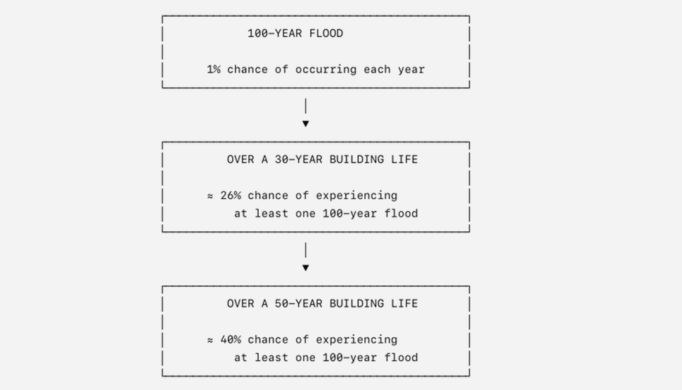
Figure 1. A 1% annual chance becomes much more consequential when viewed across a facility’s expected lifecycle.
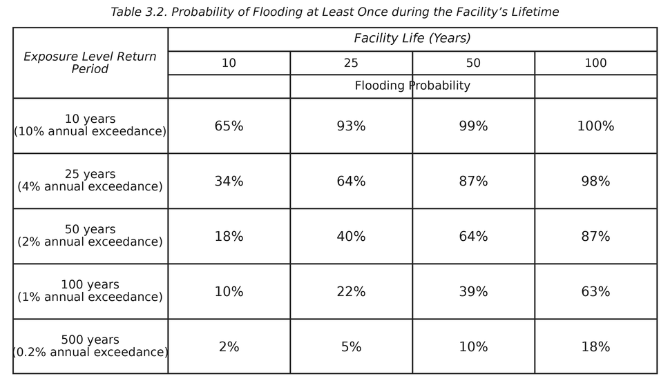
Figure 2. FM Property Loss Prevention Data Sheet 1-40 (Flood) shows how the probability of flooding accumulates over a facility’s operating lifecycle for several annual exceedance levels.
3. Local site conditions must shape engineering decisions
Identifying potential flood exposure on a map is only the beginning. Understanding how flooding will behave at a specific property requires a site-level review that no legacy or broad flood map can replace.
A qualified engineering review should examine the physical conditions that determine how water moves through a property and what vulnerabilities exist, including:
- Rainfall intensity
- Drainage capacity
- Elevation and site configuration
- Historic and changing climate trends
- The age of available engineering information, as land use often changes over time
Those conditions determine how flooding will behave and raise four key questions:
- How quickly will flooding arrive?
- How deep will the water be?
- How long will flooding last?
- What type and duration of flooding can the facility’s operations tolerate?
The answers directly influence which mitigation solutions are appropriate. A facility situated near a large river, for example, may have hours or days of warning before flooding arrives. A mountainous site may have only a few minutes. Those operational differences can help determine whether permanently installed flood barriers, rapidly deployable flood doors or other solutions are feasible—and whether staff will be available to deploy them in time.
Once flood behavior at a specific site is understood, engineers can evaluate mitigation options against five key factors identified in FM Property Loss Prevention Data Sheet 1-40 (Flood): initial investment, deployment time, human element response, business interruption and ongoing training. A solution may be technically sound but poorly suited to a facility if it cannot be deployed within the available warning time, requires personnel who may not be on site when flooding arrives or blocks critical access for too long.
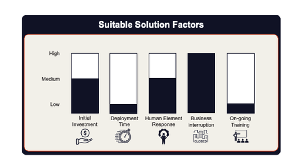
Figure 3. Evaluating flood mitigation solutions against site-specific conditions—including available warning time, deployment requirements and operational tolerance—helps engineers identify an appropriate option for a given facility.
Once site conditions and flood behavior are understood, developers and other stakeholders can seek and implement the appropriate FM Approved flood mitigation equipment as part of a broader resilience strategy.
FM Approval Standard 2510 (Flood Mitigation Equipment) requires applicable component and material testing, along with equipment-specific performance testing. Flood mitigation products that are tested and certified to FM 2510 are listed in the Approval Guide, allowing stakeholders to verify that specified equipment has been evaluated for its intended application.
Plan for flood resilience when the skies are clear
A qualified engineering team can connect the appropriate mapping and site-specific flood behavior with FM Approved equipment evaluated for its intended application. Advanced resilience planning with FM Approvals Insights, FM Property Loss Prevention Data Sheet 1-40, the Examination Standards and the Approval Guide avoid a scenario where the team responsible for the well-being of a facility must scramble to react to imminent floodwaters. Preparedness breeds resilience, and both FM and FM Approvals provide strategies and resources that help protect today against extreme climate hazards, in preparation for a better tomorrow.